

![[Espainia][Diogo Homen]Eskuizkribualeku gabe [1559]](https://imagovasconiae.eus/wp-content/uploads/2024/03/22-1.jpg "22-1")
![[Espainia][Diogo Homen]Eskuizkribualeku gabe [1559]](https://imagovasconiae.eus/wp-content/uploads/2024/04/22.jpg "22")
Description
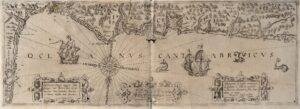
Several 16th- and 17th-century nautical, portulan charts identify the Basque territory either as “Bifcaia”, “Biscaien”, “Biscaya” or as “Navara”, “Nauarre”. Another portulan chart presumably crafted at the workshop of Caloiro-Oliva shows both “Biscaia” and “Navarra”, with the latter extending to the north of the Pyrenees.
![Tab II Europae/Hispaniam ac Lusitaniam[Gerard Mercator][G. Kempen][Kolonia] [1578]](https://imagovasconiae.eus/wp-content/uploads/2024/03/21-1-300x231.jpg)
![HispaniaEg. g.Arg. g[XVI. mendea]](https://imagovasconiae.eus/wp-content/uploads/2024/03/5-1-300x246.webp)
![[Tabula II Europae][Laurent Fries][Joannes Grüninger][Estrasburgo] [1522]](https://imagovasconiae.eus/wp-content/uploads/2024/03/8-1-300x218.webp)
